There is lots of BLM Land surrounding Anza Borrego Desert State Park. Much of it lies adjacent to the southern half of the Park. There is a mixture of BLM “public land” and BLM “wilderness”. Both are open for camping, however vehicles are not allowed inside BLM wilderness.
Finding BLM Land Near Anza Borrego
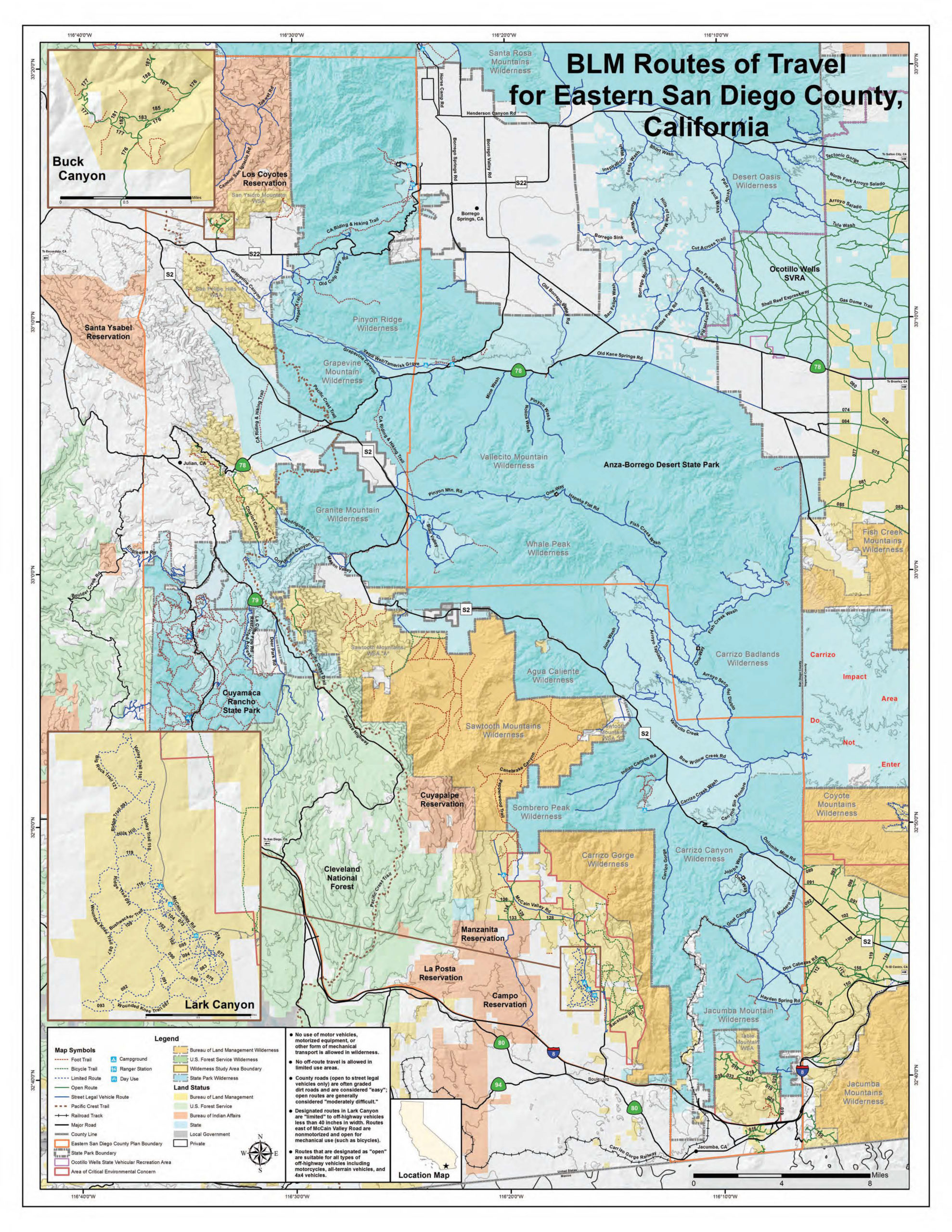
Map of Anza Borrego Desert State Park and surrounding lands…
Click here to view this map in full size PDF


| BLM Land, Public, vehicles allowed |
| BLM Land, Wilderness, vehicles not allowed |
| State Land, Public |
| State Land, Wilderness |
Best BLM Camping Near Anza Borrego
Your best bets for BLM camping near Anza Borrego Desert State Park are going to be…
- Coyote Mountains Wilderness – Located at the south-eastern portion of the park, see far-right of map. Though this is BLM Wilderness, and vehicles are not allowed into this area, there is BLM public land that fronts it. Road 093 leads through here (leading from County Road S2). Right where the Road 093 meets the Wilderness boundary, there are plenty of available camping sites. GPS for this area is (32.803753, -116.075627). Very little Verizon 4G signal here. Tent camping is still permissible inside the Wilderness, but you’ll have to hike your gear into that area.
- Dos Cabezas Road – Located just south of Coyote Mountains Wilderness, Dos Cabezas Road branches off of County Road S2 and leads through BLM public land before it enters Anza Borrego Desert State Park. There is plenty of dispersed camping here. It gets very windy, however. There are also numerous windmills scattered throughout. It’s still open for camping; just don’t camp right on a windmill platform. There are also numerous spur roads branching off. Verizon 4G is spotty throughout. Begin your drive at GPS: (32.753545, -116.048901) and drive south and west from there.
- Table Mountain WSA – This is a Wilderness Study Area, which is different than just “Wilderness”. Vehicles are allowed here. It’s located at the very southern tip of Anza Borrego Desert State Park. It’s reachable from Carrizo Creek Road, just south of Interstate 8. It’s a very popular area for boondockers. Begin your drive at GPS: (32.636460, -116.126978) and head north from there.
- Sawtooth Mountains WSA – This is a Wilderness Study Area, which is different than just “Wilderness”. Vehicles are allowed here. It’s located adjacent to Sawtooth Mountains Wilderness, at the north-west side. On the above map, you’ll find Sawtooth Mountains Wilderness in the center (in dark yellow), with the WSA located to its north-west. It’s popular with boondockers because County Road S2 runs right by it. Mason Valley Truck Trail is the primary road that runs through the WSA. There is very little Verizon 4G signal here. Enter the Mason Valley Truck Trail at GPS: (33.007513, -116.456406) and head west from there.
- Lark Canyon Campground – This is located by the south-west portion of Anza Borrego Desert State Park. It’s accessed by McCain Valley Road, which leads from Old Highway 80. Lark Canyon Campground is a developed campground. As such, it requires a fee. Cost has been $6.00 per night. It was closed due to COVID-19. GPS for the campground is: (32.727884, -116.273656)
- Cottonwood Campground – This is another developed campground located further up the road from Lark Canyon Campground (see above). Cost had been $6.00 a night. It was closed due to COVID-19. GPS for the campground is: (32.800240, -116.338262)
- Buck Canyon – This is located adjacent to the north-west portion of Anza Borrego Desert State Park. On the above map, there is an inset at the upper left-hand corner. It’s accessed by Old Mine Road, which leads from County Road S22. Old Mine Road runs through some privately owned land, about a mile in length. However, the road remains a public easement. Once you get into BLM land, there are numerous camping sites. The BLM portion begins at GPS: (33.225446, -116.559374) continue north from there.
Free Camping Inside Anza Borrego Desert State Park
Anza Borrego Desert State Park is the only California State Park that allows free, dispersed camping. The Park does have a few fee-based campgrounds, and they also have a lot of “wilderness area” where camping is not allowed. On the map above, the light blue shade represents State Land, while the darker shade of blue represents State Wilderness Land.
Read more about free camping at Anza Borrego at our other article, “Can You Camp Anywhere in Anza Borrego Desert State Park“.