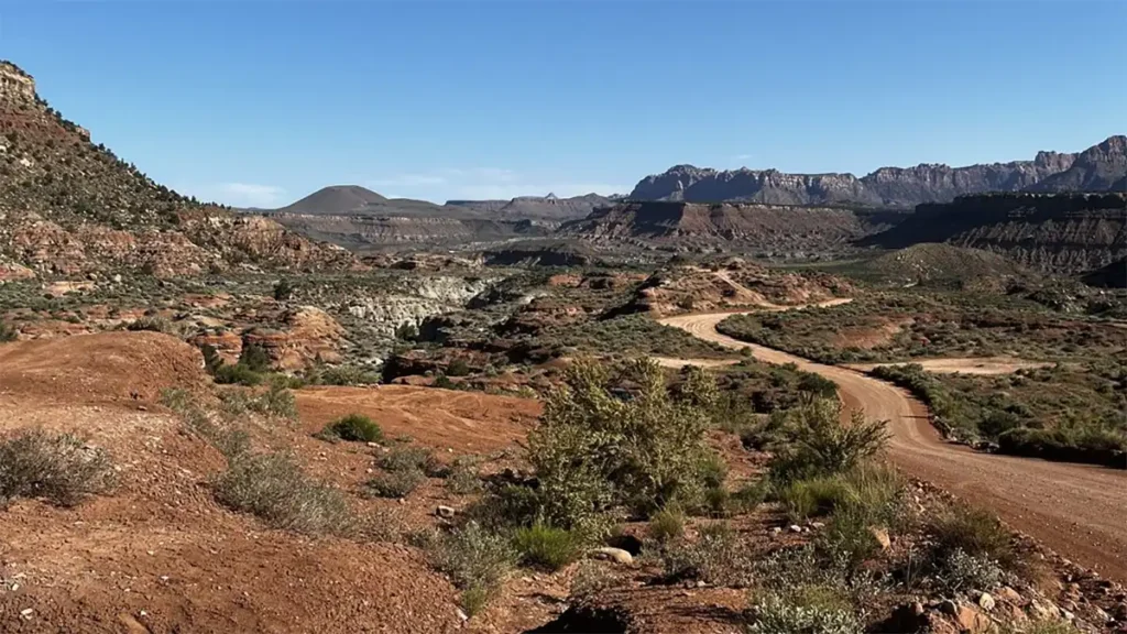
Smithsonian Butte Road runs south from Rockville, UT, which lies about 15 minutes away from Zion National Park. Camping is not allowed along Smithsonian Butte Road, but it is permitted along a couple of spur roads that stretch across Wire Mesa and Grafton Mesa. We put together a Smithsonian Butte Road camping map depicting these campsites.
This map depicts all the popular boondocking and dispersed camping locations along two spur roads leading from Smithsonian Butte Road…
Campsites depicted in the map above are not official campsites designated by the Bureau of Land Management (BLM). They are simply locations meeting camping rules for Smithsonian Butte Road and where people often boondock or disperse camp.
There are no camping fees, permits, or passes required to camp from Smithsonian Butte Road.
Smithsonian Butte Road Camping Rules
The following rules are set by the Utah BLM, St. George Field Office…
- Camping is not allowed for 1/2 mile on either side of Smithsonian Butte Road, S. Bench Rd, and Main St. You must camp at least 1/2 mile away from either side of the road.
- Vehicles (including bicycles) are not allowed to enter lands on the south side of Smithsonian Butte Road (S. Bench Rd). This is Canaan Mountain Wilderness, and is subject to prohibitions under the Wilderness Act of 1964. Camping is still allowed, but must be brought in by foot or horseback (See “Canaan Mountain Wilderness” below for more details.
- There is a 14-day camping limit within a 26-day period, over a 30-mile radius, specifically for campsites along Wire Mesa and Grafton Mesa.
- See also general camping rules set by Utah BLM.
Smithsonian Butte Road Dispersed Camping Areas
Based on the above camping rules, camping along Smithsonian Butte Road is largely restricted to two areas depicted in the map above…
- Wire Mesa – (truck trail begins at GPS 37.13136, -113.06963) – There are at least five sites along this Mesa, possibly as many as ten depending on current conditions.
- Grafton Mesa – (truck trail begins at GPS: 37.13077, -113.09821) – There are at least eight sites along this Mesa, possibly as many as twelve depending on current conditions.
Warning: 4WD vehicles are highly recommended when reaching campsites along Wire Mesa and Grafton Mesa mostly due to ruts, washes, and areas of soft sand. Also, when it rains this area gets muddy. Otherwise, Smithsonian Butte Road itself supports 2WD vehicles.
Smithsonian Butte National Back Country Byway
This is the official name of Smithsonian Butte Road. It’s actually comprised of three segments:
- Smithsonian Butte Road – which starts at the north end near the Virgin River and changes names to S. Bench Rd.
- S. Bench Rd. – which takes over from Smithsonian Butte Road right at the beginning of Wire Mesa and continues south-west.
- Main St. – which takes over from S. Bench Rd right where Grafton Mesa trail begins, and then continues south towards Apple Valley.
Camping Within Towns of Rockville and Apple Valley
Smithsonian Butte Road starts in the town limits of Rockville and ends in the town limits of Apple Valley.
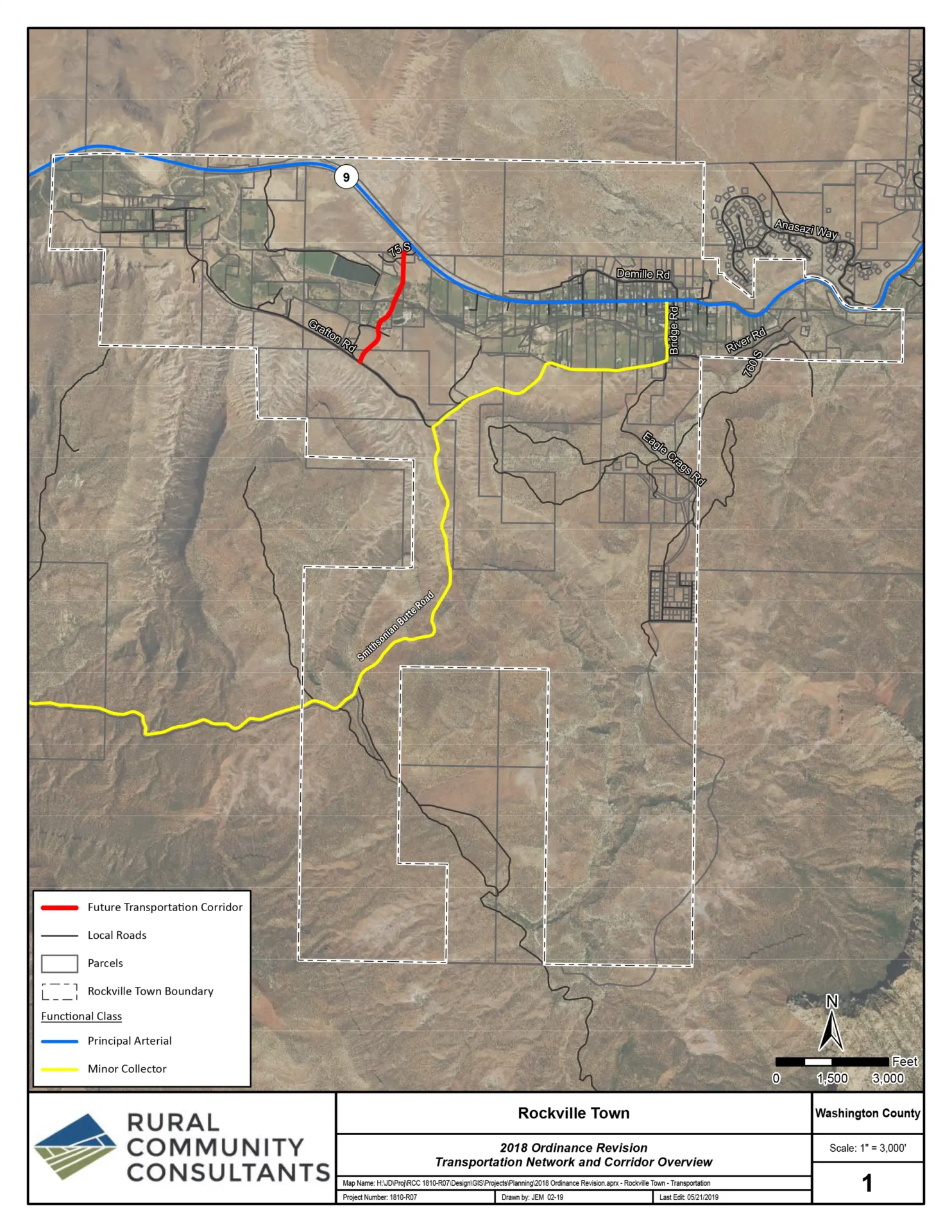
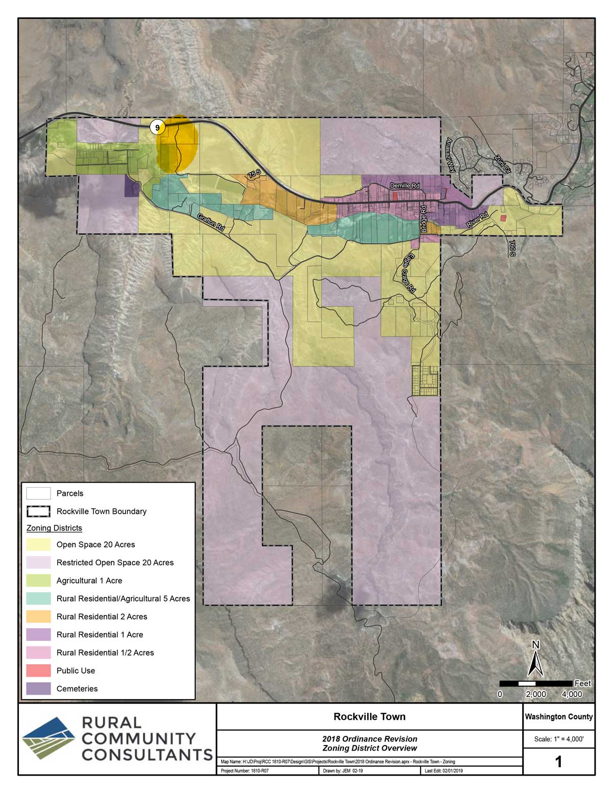
Town of Rockville: Rockville’s boundaries stretch over half of Smith Butte National Back Country Byway up to Wire Pass truck trail (see Rockville’s transportation map). Camping is allowed within Rockville’s boundaries, as long as you’re on lands zoned as, “Restricted Open Space” (ROS) (see city zoning map), which includes all of this land. The city imposes a limit of “14 days in any one location and must meet current Bureau of Land Management guidelines”. (see Zoning Ordinance 8.13.4).
- Note: there is a bridge with low clearance over Virgin River that you must cross if approaching from Rockville. A sign on the bridge says “14 Ft”, though others have stated it’s more like 13’4″.
Town of Apple Valley: Apple Valley’s boundary begins at 0.4 miles south of Grafton Mesa trail. The city has not addressed the issue of camping on lands zoned as “Open Space Conservation” (OSC), which includes all lands that Smithsonian Butte Road runs through. Refer to Apple Valley’s Zoning Ordinance 10.10.070 “Open Space Zone”. Also refer to Apple Valley’s Parcel Map.
See the official map of Smithsonian Butte National Back Country Byway published by the BLM.
Canaan Mountain Wilderness
Important: No vehicles are allowed inside Canaan Mountain Wilderness due to restrictions under the Wilderness Act of 1964. Canaan Mountain Wilderness borders up against the south side of S. Bench Rd (see above map). Camping is still allowed inside wilderness, it just has to be done without a vehicle (including bicycles). Read, “Can You Camp in a Wilderness Area?” for more details.
Campfire Rules
Utah BLM offers the following recommendations for campfires while dispersed camping…
- Be aware of any current fire restrictions listed on www.utahfireinfo.gov.
- Use existing fire rings or use a fire pan.
- Collect only dead and down wood; do not cut limbs.
- Do not leave fires unattended.
- Drown and stir your campfire before you go to bed or leave your site.
Our Advice for Camping at Smithsonian Butte Road
- If your vehicle does not have 4WD, we strongly recommend entering from the south along Main St at Apple Valley, UT. This avoids having to climb the 200 feet of steep dirt road from the north at Rockville.
- If your rig is taller than 13’4″ then do not approach from Rockville, due to the bridge over Virgin River with low clearance.
- Large motorhomes and trailers are not recommended due to smaller campsites. Small to medium-sized RVs are okay as long they have high ground clearance.
- It’s worth overnighting at the RV Park in Apple Valley (see Google Map link) and then explore boondocking sites in your tow vehicle or toad.
[sc name=”utah-footer-links”][/sc]